


North and Central Texas
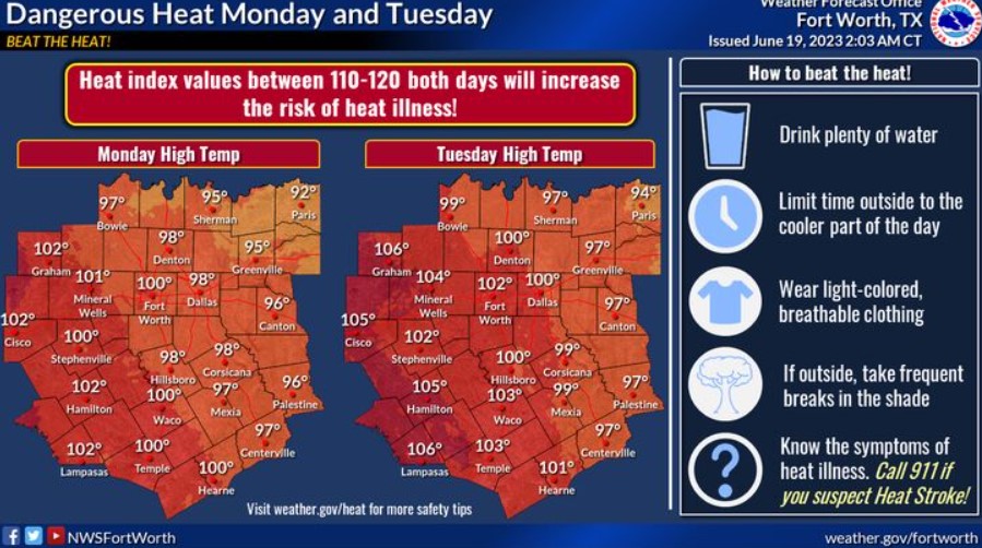
Monday and Tuesday will be hot, with highs in the 90s to 100s. Heat index values will be well above 100 on both days. Take precautions to BEAT THE HEAT! Drink plenty of water, limit time outside until evening, wear light-colored clothing, and take frequent breaks in the shade. Last but not least, know the symptoms of heat illness and CALL 911 if you suspect heat stroke! It could save your or someone else’s life!
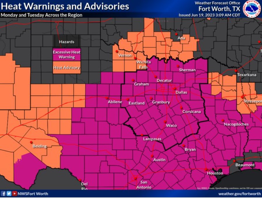
An Excessive Heat Warning is in effect until 8:00 pm Tuesday with heat index values of 110-120 degrees. This heat is dangerous, and you should take precautions. Drink plenty of water, avoid extended time outdoors, and know the signs of heat-related illness!

There is a 20% chance of isolated storms again this afternoon and tonight. Some may be severe. The main threats would be damaging wind gusts and large hail. The best time for thunderstorms is between 2:00 and 4:00 pm across Western Central Texas. Overnight storms are possible across northeast Texas after 3:00 am. Large hail would be the primary concern with this activity.
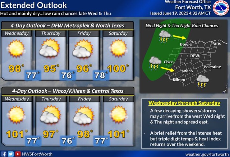
The heat and humidity continue through most of the week. Slightly cooler temps are forecast for Thursday and Friday but will be short-lived as the intense heat returns next weekend. Make sure to continue to practice heat safety.
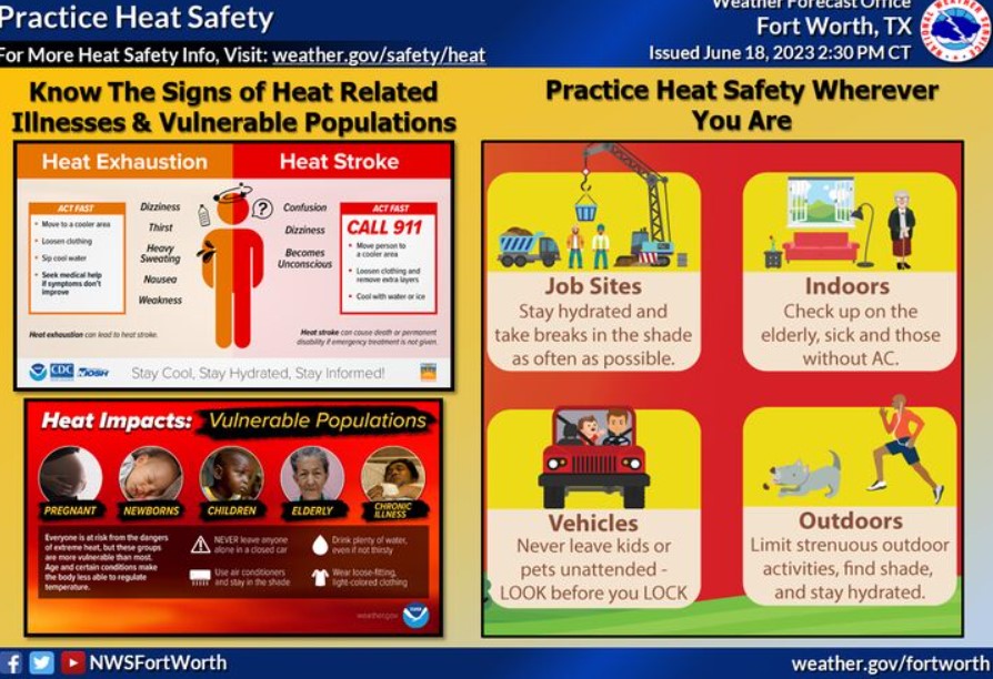
With this persisting heat, practice heat safety wherever you are! Know the signs of heat illness, and check on the more vulnerable populations. Drink plenty of water, avoid extended time outdoors during the day’s heat, and look before you lock!
Today and Tonight
Isolated thunderstorms are possible this afternoon across Western Central Texas. Large hail and damaging winds will be the main threats if storms develop.
Additional storms are possible late tonight and early Tuesday morning across East Texas. Large hail would be the main threat to this activity.
Oppressive heat and humidity will increase the threat of heat illnesses if you do not take precautions. Make sure to drink plenty of water, wear light-colored clothing, and take frequent breaks if spending time outdoors.
Tuesday through Sunday
Oppressive heat and humidity will continue through at least Wednesday. There is a low chance of thunderstorms Wednesday and Thursday nights.
SPOTTER INFORMATION STATEMENT
Do not expect spotter activation at this time.
South Central and Southwest Arkansas, North Central and Northwest Louisiana, Southeast Oklahoma, and East and Northeast Texas
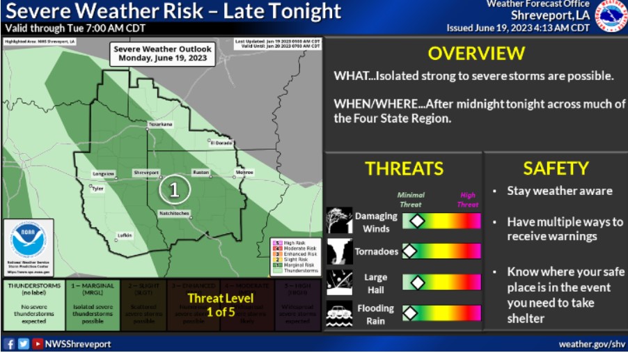
There is a risk for isolated strong to severe thunderstorms across much of the region after midnight tonight near a stationary front. Locally gusty winds and hail will be the primary threats.

Temperatures this afternoon will again climb into the mid to upper 90s, and when combined with the high humidity, will result in heat indices ranging from 105-110 degrees across the Heat Advisory area and 111-114 degrees across the Excessive Heat Warning area. These heat products are in effect until 8 pm this evening.
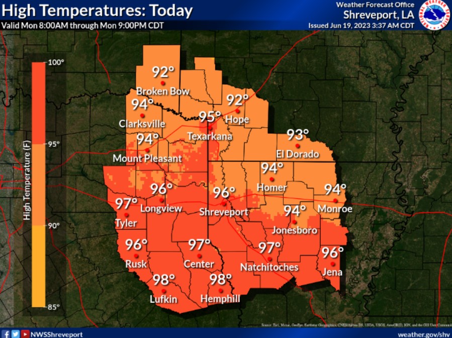
Hot and humid conditions will continue today, with temperatures climbing into the mid and upper 90s over much of the region.
Today and Tonight
Please listen to NOAA Weather Radio or go to weather.gov on the Internet for more information about the Heat Advisory. After a hot and dry day, we will see the chance for thunderstorms again overnight. The air will still be unstable, and we could see some large hail or damaging winds from substantial to severe thunderstorms.
Tuesday through Sunday
Aside from more early summer heat, no other hazardous weather is expected at this time.
SPOTTER INFORMATION STATEMENT
Do not expect spotter activation at this time.